Multi-Hazard Mitigation Plans
Oklahoma Communities have employed Flanagan & Associates, LLC to coordinate, research and assemble Multi-Hazard Mitigation Plans in accordance with FEMA guidelines. Using the process developed by Ron Flanagan's organization, accurately identify hazards, mitigation strategies and develop a plan for implementation and maintenance of mitigation plans. FEMA has reviewed and accepted the Tulsa, Oklahoma Multi-Hazard Mitigation Plan developed by Flanagan & Associates, LLC. Plans have been completed, approved by the State of Oklahoma and submitted to FEMA for review and approval. See the communities here.
Hazard Mitigation Grant Program Workshops
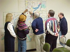
 At the request of the State of Oklahoma Flanagan & Associates, LLC hosted five workshops at various locations in the state during 2003 and another Workshop was held in 2004 describing what Hazard Mitigation Planning is, why it is important to communities, counties and tribes and options on how to create a plan. Connie Dill, from the Oklahoma Department of Emergency Management, and Ron Flanagan took workshop participants through each phase of creating a Hazard Mitigation Plan, showed examples of successful plans and provided information and resources to participants. At the request of the State of Oklahoma Flanagan & Associates, LLC hosted five workshops at various locations in the state during 2003 and another Workshop was held in 2004 describing what Hazard Mitigation Planning is, why it is important to communities, counties and tribes and options on how to create a plan. Connie Dill, from the Oklahoma Department of Emergency Management, and Ron Flanagan took workshop participants through each phase of creating a Hazard Mitigation Plan, showed examples of successful plans and provided information and resources to participants.
Elm Creek
 The Elm Creek basin consists of 3.4 square miles of fully-urbanized inner city east of, and adjacent to, downtown Tulsa, Oklahoma. The basin is totally developed with urban land-uses, consisting primarily of older single-family residences and retail and service commercial uses along the major streets. The Elm Park Relief Sewer System was designed in 1922 to accommodate rainfall amounts no greater than would occur on an average of once in 10 to 15 years based on rainfall information available at that time. Urbanization in the watershed since then has served to overload the main sewer system as well as its contributing conduits. The 15-foot high arch storm sewer is buried as much as 60 feet beneath the City in places and enters the Arkansas River just downstream of the 21st Street Bridge. The Elm Creek basin consists of 3.4 square miles of fully-urbanized inner city east of, and adjacent to, downtown Tulsa, Oklahoma. The basin is totally developed with urban land-uses, consisting primarily of older single-family residences and retail and service commercial uses along the major streets. The Elm Park Relief Sewer System was designed in 1922 to accommodate rainfall amounts no greater than would occur on an average of once in 10 to 15 years based on rainfall information available at that time. Urbanization in the watershed since then has served to overload the main sewer system as well as its contributing conduits. The 15-foot high arch storm sewer is buried as much as 60 feet beneath the City in places and enters the Arkansas River just downstream of the 21st Street Bridge.
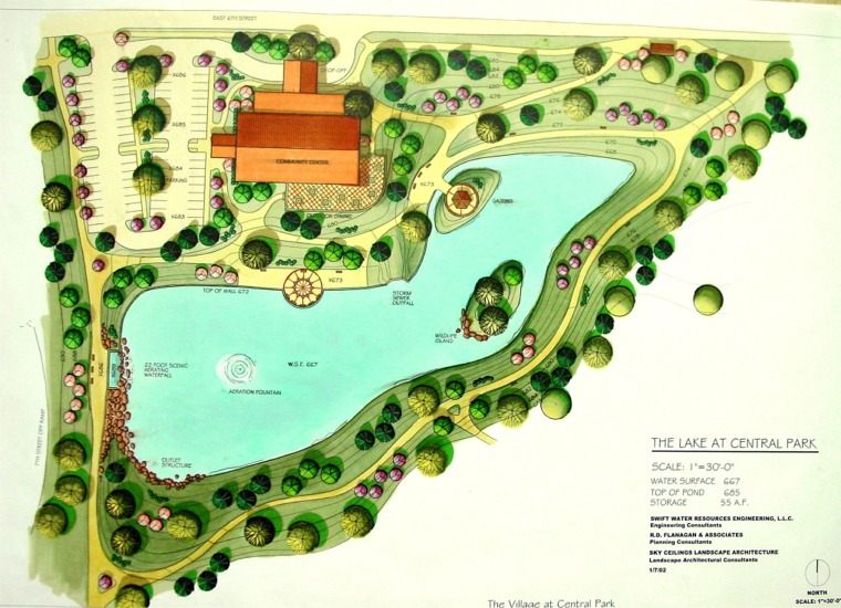
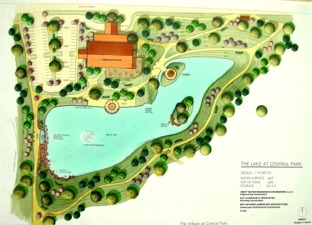
 Central Park, excluding the City's senior citizen recreation center and portions of its parking lot, will serve as a proposed detention facility. Though the facility will be largely excavated, a low-flow channel will contain and fully convey runoff up to the 5-year event. This will preserve the park setting except in extreme storm events. The channel will replace the arch storm sewer within the pond. The final design may incorporate an enclosed conduit instead of the open channel to further utilize park area. The final facility surface area will be 13.5 acres with a peak 100-year storage volume of 129.7 acre-feet. The maximum ponding depths will range from 8.0 feet in the upper reaches of the facility to 18.0 feet at the outlet. Storm runoff will enter the facility from three primary locations; the storm sewer running along Norfolk Avenue, the 6th Street existing culvert and proposed pipe (or equivalent box) located near 6th Street. The outlet control of the facility will be a 160-square-foot restrictive opening situated at the entrance to the arch storm sewer near the intersection of Madison Avenue and 8th Street. Central Park, excluding the City's senior citizen recreation center and portions of its parking lot, will serve as a proposed detention facility. Though the facility will be largely excavated, a low-flow channel will contain and fully convey runoff up to the 5-year event. This will preserve the park setting except in extreme storm events. The channel will replace the arch storm sewer within the pond. The final design may incorporate an enclosed conduit instead of the open channel to further utilize park area. The final facility surface area will be 13.5 acres with a peak 100-year storage volume of 129.7 acre-feet. The maximum ponding depths will range from 8.0 feet in the upper reaches of the facility to 18.0 feet at the outlet. Storm runoff will enter the facility from three primary locations; the storm sewer running along Norfolk Avenue, the 6th Street existing culvert and proposed pipe (or equivalent box) located near 6th Street. The outlet control of the facility will be a 160-square-foot restrictive opening situated at the entrance to the arch storm sewer near the intersection of Madison Avenue and 8th Street.
Community Rating System (CRS)
 A 1976 study identified Tulsa, Oklahoma as the most flood-prone community in the nation. Due to the dedicated effort of citizens and the government, less than 20 years later Tulsa was generally recognized as having the best floodplain management program in the nation. A 1976 study identified Tulsa, Oklahoma as the most flood-prone community in the nation. Due to the dedicated effort of citizens and the government, less than 20 years later Tulsa was generally recognized as having the best floodplain management program in the nation.
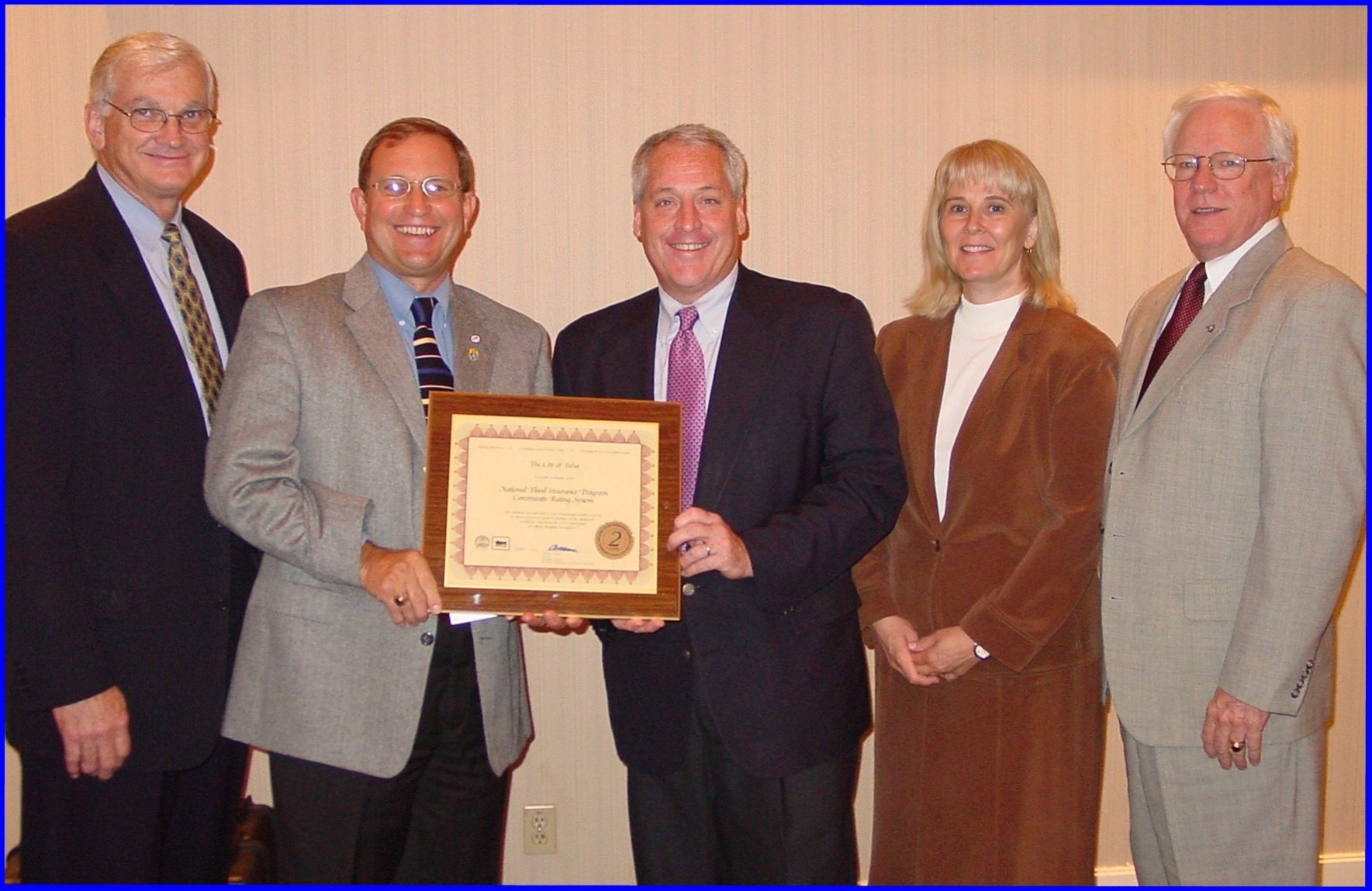
In September 2003 the City of Tulsa was honored by FEMA under the Department of Homeland Security for becoming the first city in the nation to receive a Community Rating System rating of 2. As a result Tulsans in the Special Hazard Flood Areas receive a 40% discount on flood insurance.
Flanagan & Associates, LLC has provided planning consultation to the City of Tulsa's CRS Program since 1990. The City of Tulsa has used Flanagan & Associates, LLC as the primary consultant for their recertification and three-year cycle re-applications / verifications.
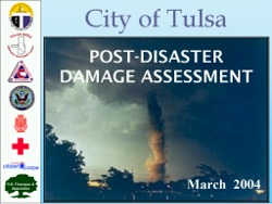
Tulsa Damage Assessment Training
 Damage assessment following a disaster: Damage assessment following a disaster:
- Identifies types and extent of damages.
- Provides information to decision makers.
- Identifies response needs.
- Identifies impact on individuals and community
Flanagan & Associates, LLC along with the City of Tulsa, Tulsa Area Emergency Management Agency, Oklahoma Department of Emergency Management, FEMA, American Institute of Architects, American Red Cross and Tulsa Citizen Corps developed a program for training city employees and volunteers on performing damage assessments following a disaster.
Mingo Creek Greenway Corridor
 Mingo Creek basin in Tulsa, Oklahoma had caused over $216 million in flood damages since 1959 and $180 million in property damage and the loss of five lives in 1984. Plans designed to control flooding were developed. The City of Tulsa retained Flanagan & Associates, LLC to review the designs, work with the U.S. Corps of Engineers and to develop and refine an alternative plan sensitive to the ecological, visual and cultural needs of the community. This effort resulted in the development of an open Mingo Creek basin in Tulsa, Oklahoma had caused over $216 million in flood damages since 1959 and $180 million in property damage and the loss of five lives in 1984. Plans designed to control flooding were developed. The City of Tulsa retained Flanagan & Associates, LLC to review the designs, work with the U.S. Corps of Engineers and to develop and refine an alternative plan sensitive to the ecological, visual and cultural needs of the community. This effort resulted in the development of an open 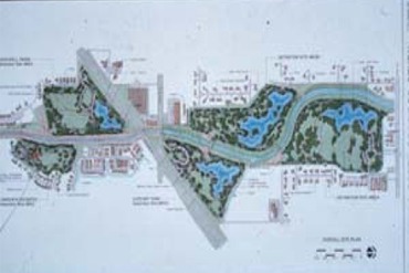 multi-jurisdictional, multi-objective design process that changed the way drainage and flood control facilities are planned and designed. multi-jurisdictional, multi-objective design process that changed the way drainage and flood control facilities are planned and designed.
The Mingo Creek Stormwater Detention Facilities are designed to serve as park, recreation and space facilities. The project was selected by the National Park Service, Association of State Floodplain Managers, and the Association of State Wetland Managers as one of eight case studies throughout the nation of successful multi-objective river corridor management examples.
San Antonio River
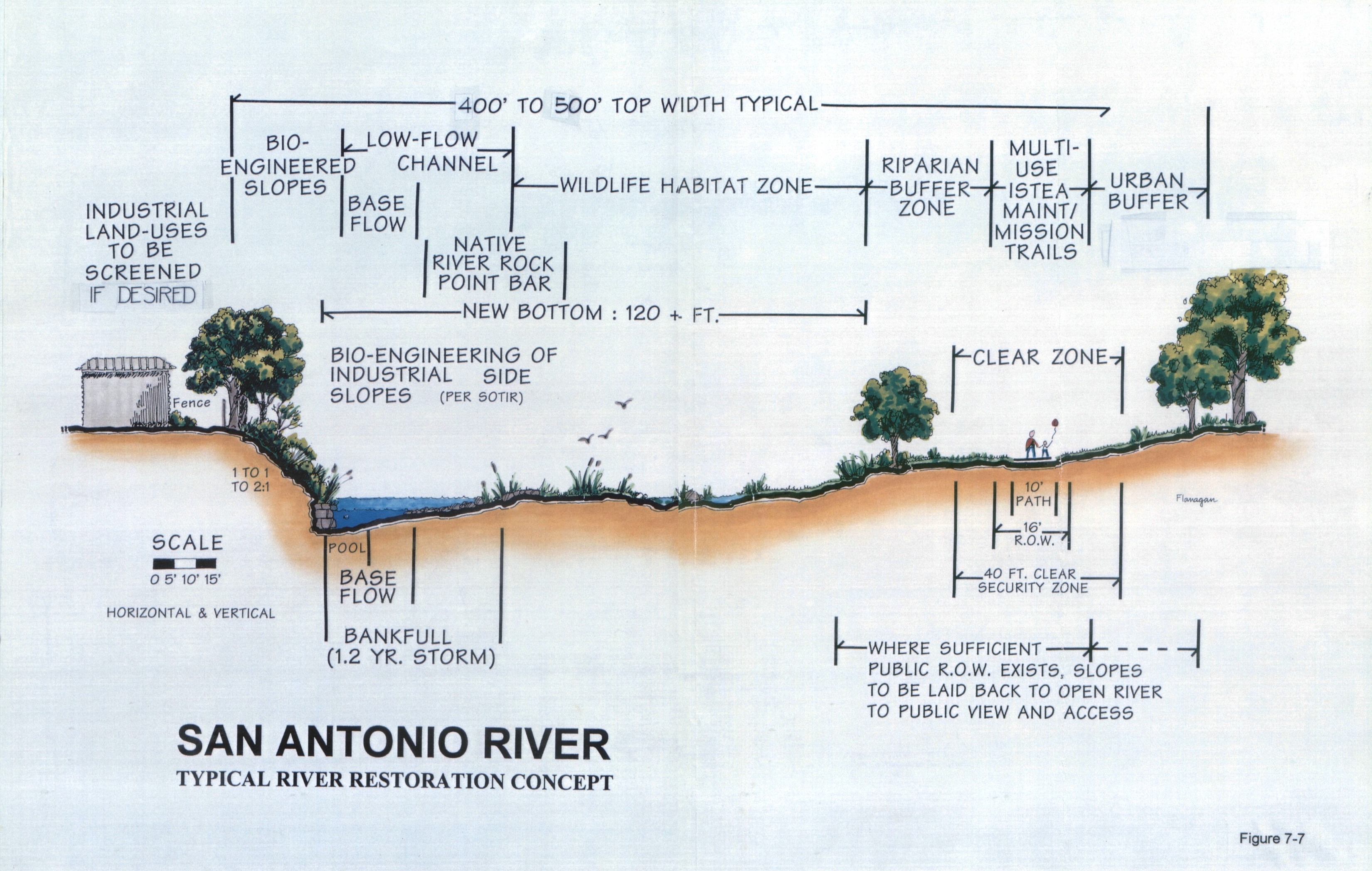
 Flanagan & Associates, LLC were selected as planning consultants in 1996 by the San Antonion River Authority, The City of San Antonio, Texas, and Bexar County, to develop a plan for the extension of the San Antonio River Walk though the heart of San Antonio. Flanagan & Associates, LLC were selected as planning consultants in 1996 by the San Antonion River Authority, The City of San Antonio, Texas, and Bexar County, to develop a plan for the extension of the San Antonio River Walk though the heart of San Antonio.
The multi-disciplinary team, consisting of Freese and Nichols, Inc., engineering consultants, Jim Richards Studio, landscape architects, Robert Searns, trails planner, Robbin B. Sotir & Assocaties, bioengineering, and Jaster Quintanilla & Associates developed the conceptual plan for the 3.7 mile extension of the famous River Walk. The plan serviced as the basis for subsequent work and detailed plans.
Vensel Creek Master Drainage Plan
Flanagan & Associates, LLC was retained by the Engineering Department, City of Tulsa, to develop a process for the comprehensive planning of drainage basins within the city. The project included performing a pilot study on a developing basin in south Tulsa and development of a standard planning format for subsequent studies.
Consultants conducted a national study on the state-of-the-art in developing watershed master drainage planning process and worked with city engineering staff responsible for developing hydraulic and hydrologic models. Consultants in turn developed the study format, identified drainage characteristics, problem areas, conducted the resource inventory, zoning and land-use inventory and full urbanization projections and developed the Vensel Creek park, recreation, and open-space plan.
 Consultants were responsible for public information and education, planning and conduct of public input, participation and presentation meetings. The final work product was the development of Tulsa’s first master drainage and trails plan. Consultants were responsible for public information and education, planning and conduct of public input, participation and presentation meetings. The final work product was the development of Tulsa’s first master drainage and trails plan.
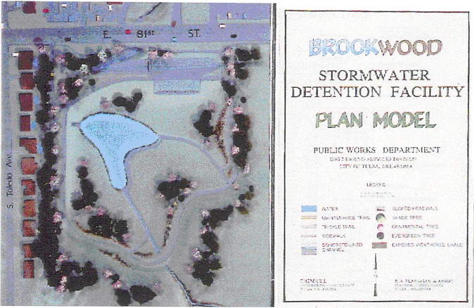
Since the Vensel Creek Trail Plan the City of Tulsa has completed master drainage plans on all drainage basins and multi-use trails within its jurisdiction of over 150 square miles. Detailed design and implementation plans were developed for the Brookwood Detention Facility. This plan involved extensive citizen participation and resulted in a park-like facility with a permanent water feature, landscaping and trails.
Cooley/Tupelo Corridor Plan
Flanagan & Associates, LLC was the design team leader in a consortium of planners and landscape architects retained to develop multi-use plans and detailed designs for eight regional stormwater detention facilities in the Cooley and Tupelo Creeks drainage basins. The drainage basins are major tributaries to Mingo Creek in eastern Tulsa.
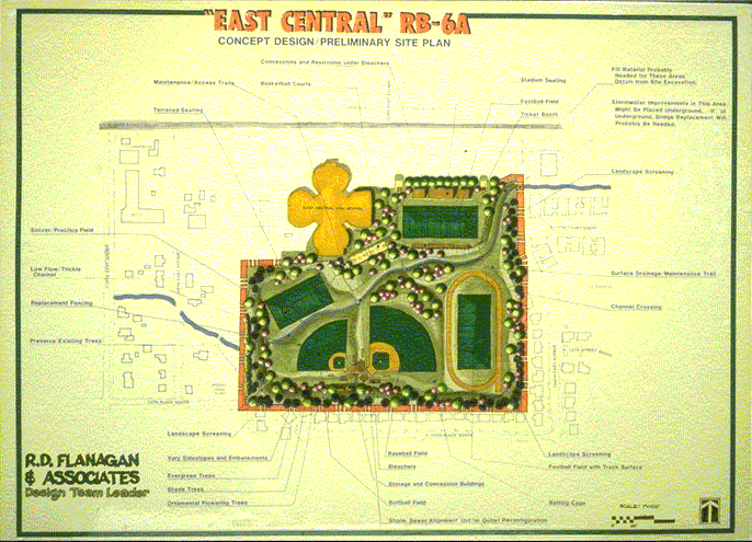
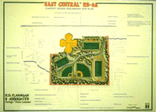 Each of the eight sites and their greenway corridors were unique and required individual analysis and design treatment. The East Central High School site was located on the site of the community high school and the design had to incorporate a football field and stadium as well as a soccer field and two baseball diamonds. The Wright Middle School site incorporated baseball diamonds, soccer fields and jogging trails into the design. Each of the eight sites and their greenway corridors were unique and required individual analysis and design treatment. The East Central High School site was located on the site of the community high school and the design had to incorporate a football field and stadium as well as a soccer field and two baseball diamonds. The Wright Middle School site incorporated baseball diamonds, soccer fields and jogging trails into the design.
The Holiday Park site, located at the intersection of two expressways and a major street, was designed to accommodate a City of Tulsa Training Facility.
The Cooley Lake and Sampson Lake sites were designed to serve as passive recreation facilities with a permanent water feature and trail systems. The Tupelo site was a challenging redesign and retrofit of an older existing detention facility. The design team transformed the rather unattractive, single-purpose facility into a multi-use site with a permanent water feature, re-forestation, site sculpting, baseball and soccer fields, and multi-use trails.
Multi-Use Maintenance Trail Plans
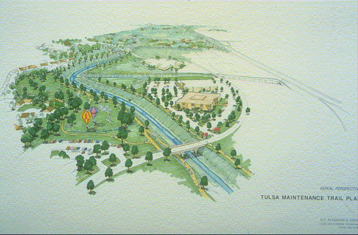
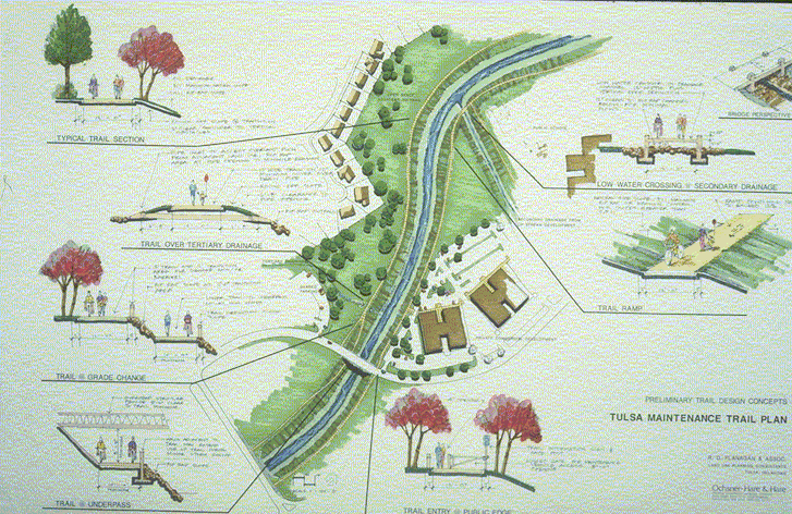
 Flanagan & Associates, LLC was contracted by the City of Tulsa to perform an inventory of 50 miles of publicly owned drainageways, identify types of ownership (easements, fee simple, dedications, private ownership, covenants, etc.), obstructions, restrictions and improvements and to develop a maintenance access and trails plan for the drainageways. The plan was to serve not only drainageway maintenance purposes, but also to serve as a multi-purpose, multi-use pedestrian and bicycle trail. Flanagan & Associates, LLC was contracted by the City of Tulsa to perform an inventory of 50 miles of publicly owned drainageways, identify types of ownership (easements, fee simple, dedications, private ownership, covenants, etc.), obstructions, restrictions and improvements and to develop a maintenance access and trails plan for the drainageways. The plan was to serve not only drainageway maintenance purposes, but also to serve as a multi-purpose, multi-use pedestrian and bicycle trail.
The project involved developing multi-use maintenance/recreation trail criteria and standards, which have subsequently been widely adopted throughout the nation as the standard for maintenance trails. The Maintenance Trail Plan was adopted and incorporated into the regional Park, Recreation and Open-Space Plan and various District Comprehensive Plans.
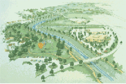
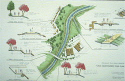
Mooser Creek Greenway Corridor
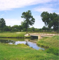 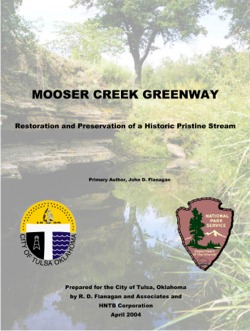 Flanagan & Associates, LLC was selected as the chief planner in assisting the City of Tulsa and the Rivers, Trails, and Conservation Assistance Program of the National Park Service in the development of a pilot greenway and trails project for the Mooser Creek Basin in southwest Tulsa. The Project focused on the efforts of all city departments and federal agencies in developing a plan for the basin; including the Natural Resource and Conservation Service, U.S. E.P.A., Corps of Engineers and the River Parks Authority. Flanagan & Associates, LLC was selected as the chief planner in assisting the City of Tulsa and the Rivers, Trails, and Conservation Assistance Program of the National Park Service in the development of a pilot greenway and trails project for the Mooser Creek Basin in southwest Tulsa. The Project focused on the efforts of all city departments and federal agencies in developing a plan for the basin; including the Natural Resource and Conservation Service, U.S. E.P.A., Corps of Engineers and the River Parks Authority.
Ron Flanagan’s solution was to create artificial detention sites that imitate nature by ponding runoff during spring and fall rains, but for the rest of the year serve as parks, playing fields and wildlife habitat.
The project involved extensive citizen involvement, interagency inter-governmental cooperation and coordination, extensive inventory, alternative development and refinement of the selected plan.
Tulsa Trails
 Flanagan & Associates, LLC developed the first Tulsa Trails Master Plan for the City of Tulsa in 1987. This first "Blue-Greenway" plan illustrated the trails concept utilizing the River Parks trail system, major drainage corridors, trafficways, and connector systems linking public facilities, parks, schools, commercial and employment centers, and stormwater detention ponds. This early trails master plan served as the basis for the later INCOG Tulsa Area Parks and Trails Plan. Flanagan & Associates, LLC developed the first Tulsa Trails Master Plan for the City of Tulsa in 1987. This first "Blue-Greenway" plan illustrated the trails concept utilizing the River Parks trail system, major drainage corridors, trafficways, and connector systems linking public facilities, parks, schools, commercial and employment centers, and stormwater detention ponds. This early trails master plan served as the basis for the later INCOG Tulsa Area Parks and Trails Plan.
|